Билэ:India and South Asia Köppen climate map with legend.jpg
India_and_South_Asia_Köppen_climate_map_with_legend.jpg (545 × 537 пииксэл, билэ кээмэйэ: 60 КБ, MIME тиибэ: image/jpeg)
Быһаарыы
| Быһаарыыта |
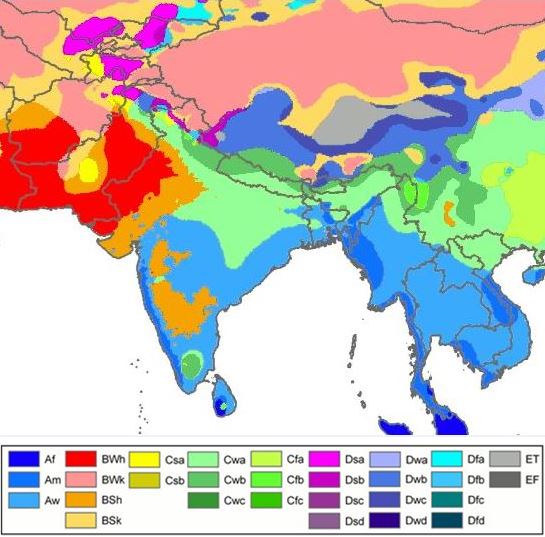
English: South Asia- Köppen-Geiger climate classification map is based on native vegetation, temperature, precipitation and their seasonality.
(Af) Tropical rainforest
(Am) Tropical monsoon
(Aw) Tropical savanna, wet & dry
(BWh) Hot desert
(BWk) Cold desert
(BSh) Hot semi arid
(BSk) Cold semi arid
(Csa) Mediterr. dry, hot summ.
(Cwa) Subtropical humid summ, dry winter
(Cwb) Subtropical highland, dry wint
(Cfa) Subtropical humid summ (no dry) |
| Күнэ-дьыла | |
| Хантан ылыллыбыта |
|
| Ааптар |
File:World Köppen Map.png: Original file by Peel, M. C., Finlayson, B. L., and McMahon, T. A. (University of Melbourne). Derivative work: Modifications by user Br-Sc-94, (User talk). Cropping & addition of map legend-color box-to summary info by 2know4power, (User talk). |
Legend
| Это отретушированное изображение, что означает, что первоначальной версия изображения была изменена цифровым способом. Изменения: Climate change in 2009. Оригинал доступен по ссылке: World Köppen Map.png:
|
Лицензиялааһын
- Эн көҥүл:
- айымньыны тарҕатыаххын сөп – төгүллүөххүн, тарҕатыаххын уонна кимиэхэ эмэ биэриэххин сөп.
- туһанан атын айымньыны айыаххын сөп – уларытыаххын сөп
- Бу усулуобуйалары тутуһуохтааххын:
- атрибуция – Ааптары, лиссиэнсийэ тиэксигэр сигэни уонна ааптар уларыппытын дуу, суоҕун дуу ыйыахтааххын. Ханнык баҕарар ньыманнан ыйарыҥ бобуллубат, ол эрээри онтукаҥ лицензиат Эйигин бэйэҕин дуу, бу маны туһанаргын дуу өйүүрүн курдук санааны үөскэтиэ суохтаах.
- эмиэ оннук усулуобуйаҕа тарҕатыллар – Өскө бу айымньыны уларытар эбэтэр кини олоҕор атын айымньыны айар буоллаххына, ол саҥа айымньыны бу айымньы лиссиэнсийэтинэн эбэтэр онно сөп түбэһэр лиссиэнсийэннэн тарҕатыахтааххын.
Explanatory notes
This map- File-India_and_South_Asia_Köppen_climate_map_with_legend.jpg is cropped from source map File:Köppen World Map (retouched version).png.[1] Some explanations are given below.
.png)
Lack of recording stations: Alps, Temperate zone in South India
Extent of Temperate climate markings ( “C” zone) in South India
In map File:Köppen World Map (retouched version).png-The Temperate climate markings ( “C” zone) are larger in Tropical South India, around Kodaikanal which is on the eastern side of Western Ghats mountains in Tamil Nadu state, at a higher elevation (~2300m). And also the temperate climate markings extend further South than expected. This is due to recordings from temperature station at Kodaikanal & lack of recording stations from nearby lowland areas, so markings could not be corrected due to lack of data.[1]
Extent of Alps in Europe marked as E zone; (Himalayas-high mountains- not marked as “E” zone)
In map File:Köppen World Map (retouched version).png-Alps high mountains are marked as “E” zone in this map. But “E” zone markings in the map for the Alps- high mountains do not cover the extent expected, because of lack of recording stations.[1] In this map, Himalayas -high mountains- are not marked as “E” zone.
Another map from a different source, shows no "C" zone in South India, Himalayas high mountains marked as "E" zone
Another map with reliable source is in references list given below. This map is based on data sets from the Climatic Research Unit (CRU) of the University of East Anglia and the Global Precipitation Climatology Centre (GPCC) at the German Weather Service.This is a digital Köppen–Geiger world map[2] on climate classification for the second half of the 20th century.
World Map of the Köppen-Geiger climate classification updated
This map[2] shows no temperate "C" zone in tropical South India & Himalayas high mountains are marked as polar "E" zone.
References
- ↑ a b c Peel, M. C. and Finlayson, B. L. and McMahon, T. A. (2007). "Updated world map of the Köppen–Geiger climate classification". Hydrol. Earth Syst. Sci. 11: 1633–1644. DOI:10.5194/hess-11-1633-2007. ISSN 1027-5606. (direct: Final Revised Paper).
- ↑ a b c d Kottek, M., J. Grieser, C. Beck, B. Rudolf, and F. Rubel (2006). "World Map of the Köppen–Geiger climate classification updated". Meteorol. Z. 15 (3): 259–263. DOI:10.1127/0941-2948/2006/0130. Retrieved on 2013-06-01.(direct- Kottek 2006 Paper)
Related maps
User Jeroenvrp made for these continents and areas a cropped and resized version:
- Africa Köppen Map.png
- Asia Köppen Map.png
- Australia-Oceania Köppen Map.png
- Europe Köppen Map.png
- North America Köppen Map.png
- Russia Köppen Map.png
- South America Köppen Map.png
- West Asia Köppen Map.png.
User LordToran made from the same data these maps:
- Klimagürtel-der-erde-eisklima.png
- Klimagürtel-der-erde-gemäßigte-zone.png
- Klimagürtel-der-erde-polargebiete.png
- Klimagürtel-der-erde-subtropen.png
- Klimagürtel-der-erde-tropen.png
- Klimagürtel-der-erde-tundra.png
- Klimagürtel-der-erde-warmgemäßigte-zone.png
- Klimagürtel-der-erde.png
- Klimagürtel-der-erde.svg
- Klimate-humidität.png
- Köppen-geiger-hessd-2007.svg
- Köppen-vereinfacht.svg
- Trockenklimate.png
Билэ устуоруйата
Ыйын-күнүн/кэмин баттаа, оччотооҕуга баар буолбут.
| Күнэ-ыйа/Кэмэ | Ойуучаан | Кээмэйдэрэ | Кыттааччы | Хос быһаарыы | |
|---|---|---|---|---|---|
| билиҥҥи | 03:28, 20 Сэтинньи 2015 | | 545 × 537 (60 КБ) | 2know4power | User created page with UploadWizard |
Билэни туттуу
Бу билэни бу сирэй туһанар:
Билэни киэҥник туттуу
Бу билэ маннык биикилэргэ туттуллар:
- Манна ast.wikipedia.org туттуу
- Манна bn.wikipedia.org туттуу
- Манна ca.wikipedia.org туттуу
- Манна cs.wikipedia.org туттуу
- Манна en.wikipedia.org туттуу
- Манна eo.wikipedia.org туттуу
- Манна es.wikipedia.org туттуу
- Манна es.wikibooks.org туттуу
- Манна fy.wikipedia.org туттуу
- Манна gu.wikipedia.org туттуу
- Манна hi.wikipedia.org туттуу
- Манна ja.wikipedia.org туттуу
- Манна lt.wikipedia.org туттуу
- Манна ms.wikipedia.org туттуу
- Манна ne.wikipedia.org туттуу
- Манна nl.wikipedia.org туттуу
- Манна simple.wikipedia.org туттуу
- Манна sl.wikipedia.org туттуу
- Манна sr.wikipedia.org туттуу
- Манна th.wikipedia.org туттуу
- Манна tl.wikipedia.org туттуу
- Манна yi.wikipedia.org туттуу